![]()
Many seventeenth and eighteenth century maps (and even a few sixteenth century maps) show an island labeled "Guanahaní" lying in the Bahamas. But it was well-known that Guanahaní was the native name for the first landfall of Columbus; his letter announcing the discovery in 1493 had mentioned the name, and had been a bestseller in Europe. How did these later cartographers get their information about Columbus's first voyage, decades or centuries after the fact? We don't know. But we do know that the island labeled "Guanahaní" on most of these maps can usually be identified as either Cat Island or Watlings Island.
The cartographic identification of Cat as the first landfall, even before the Diario was published in 1825, made Cat the early favorite in the landfall debate. Once the Diario became known, however, it became clear that Cat just didn't fit the descriptions of Columbus, and the theory was abandoned. Nevertheless, I've included old maps on the scorecard, and given Cat and Watlings favorable ratings on this clue.
 |
|
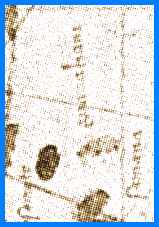
| A fragment from the Juan de la Cosa map, showing the island of Guanahaní. | |
|---|---|
As far as I'm concerned, the only old map that's really useful in the landfall debate is the map of Juan de la Cosa, which is preserved in the Museo Naval in Madrid. De la Cosa was a cartographer who was on Columbus's first voyage as the master (that is, captain) of the Santa Maria. He was also on the second voyage of Columbus, and the voyage of Alonso de Ojeda to Venezuela in 1499. In 1500 he drew a map of the world, including the newly discovered lands in the western hemisphere, including Guanahaní. This map is notable as the earliest known map that shows any part of the New World.
The la Cosa map is also critically important to the landfall debate because it is the only existing map of the landfall drawn by any member of the first voyage. (In fact, since the log of Columbus is a second-hand account, the map of de la Cosa is really the only first-hand document from the first voyage that is useful in the landfall dispute.)
The area showing the Bahamas on the map seems very confused at first glance, because de la Cosa was including information he got from others as well as his own first-hand knowledge of the area. This overlay of information leads to situations in which some islands are shown twice, and some not at all. However, if we look at Guanahaní itself, the map shows us critical features that are not immediately clear from the log of Columbus. First, Guanahaní is not a single island. De la Cosa shows it as a small group of small islets, lying on an east-west axis. Guanahaní is also shown as lying directly north of Cape Mola, the northwestern tip of Hispaniola.
Landfall theories which are multiple islands are given good scores on the scorecard, with the best scores reserved for those whose islands are small and lying east-west. Landfalls that are north of Cape Mola are also given good scores on the scorecard.
![]()
| Next clue |
Return to the landfall clues page.