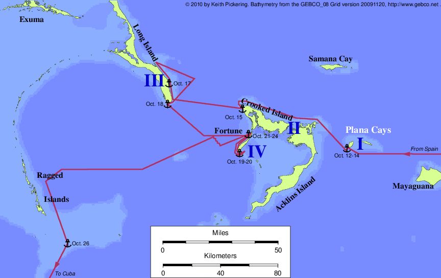
The Plana Cays theory was first proposed by Ramon J. Didiez Burgos
in his book, Guanahaní y Mayaguain, which has been almost
completely neglected since its publication in 1974. This may be in part
due to its unwelcome thesis, or perhaps due to Didiez's almost
impenetrable prose.
Didiez proposed that Mayaguana was the source of the light of
October 11, and that the first landfall was at the western of the two
Plana Cays. From that point, Didiez follows Varnhagen's route along the
north coast of Acklins and Crooked (Island II), then circumnavigating Long
Island (Island III). Fortune Island is Island IV.
The theory was revived twenty years later by Keith Pickering (yours truly) who
substituted Fox's route along the east coast of Long Island for Didiez's impossible
circumnavigation of Long. At the US Naval
Institute debate on the landfall in April 1992, moderator
William F. Buckley
awarded a TKO to the Plana theory because of its perfect fit to the most important
clue in the log: the north-south coast of Island II that faces Island I. This
is the only place in the log where Columbus tells us the direction to Island I
from any other point.
Pickering's article appeared in the history of science journal
DIO. Click here to view the DIO
article. Since that article was written, a few new wrinkles have been added. Models of
the Earth's magnetic field in historical times have been improved, indicating
a landfall in the central Bahamas (including Plana); see
my lecture on the
transatlantic track.
Also, the issue of seeing Island III from Island II, which
had been a long bugaboo, has been resolved through another application of science.
Every afternoon shortly before sunset there comes a point at which the outgoing
infrared radiation from the Earth's surface becomes greater than the incoming
solar radiation. When this happens convection in the troposphere shuts down,
the Earth's surface begins to cool, and a nocturnal boundary layer
(or NBL) begins to form. What is an NBL? The "usual" daytime situation for the
atmosphere is that the air is warmest at the surface, and cools as you go up.
That happens because the surface is absorbing heat from the sun, and getting
rid of it by convection. But when the surface begins to cool, that situation
is now reversed: the surface is now a cool sink instead of a heat source for
the air, and the air right above the surface has a temperature inversion, meaning
it's cooler as you go lower. The layer in which this temperature inversion is
present is the nocturnal boundary layer.
That's important, because the standard equations that determine the maximum
sighting distance are based on standard daytime conditions. But right before sunset,
with a temperature inversion right at the surface of the sea, and with lines
of sight to distant object skimming right though the NBL, atmospheric refraction
is higher than standard. In other words, right at this time of day, you can
actually see farther. (In fact, CC mentions this in the Diario, and nobody
ever gave it much credence.) Since in the Plana theory, CC's fleet was rounding
Bird Rock just at sunset, and since they were only just a mile beyond the
distance needed for seeing Long Island under the standard equations, even
a moderate temperature inversion would be enough to allow CC to see Long Island
at that time of day. Which is a long way of saying, I have changed the scorecard
on this clue and given Plana a 2 (up from zero) on this point. I've also
updated Samana and Mayaguana, which share the same route at this point.
The Plana Cays is the most likely landfall, not because it's a
perfect theory (there is no such thing in this debate) but simply
because it has fewer and less serious problems than any of the others
-- in some cases, a lot fewer.

Unresolved problems with the Plana theory:
- There are no references on old maps to Plana as Guanahani.
- The Plana Cays are two islands. Columbus does not specifically say
that there are two islands in the log.
- Columbus described a large pond in the middle of Island I. The
large ponds at Plana are not in the middle of the island.
- There was a peninsula with a narrow neck at Island I. There is no
such peninsula at Plana.
- Acklins Island is marginally visible from the Plana anchorage.
Columbus does not mention other visible islands until after leaving
Island I.
- The coast of Island IV does not run west from the northern
point.
- The coast of Island IV is not 12 leagues long.
And that's about it. The shortest list of the bunch.
| Landsat image of the Plana
Cays |
|---|
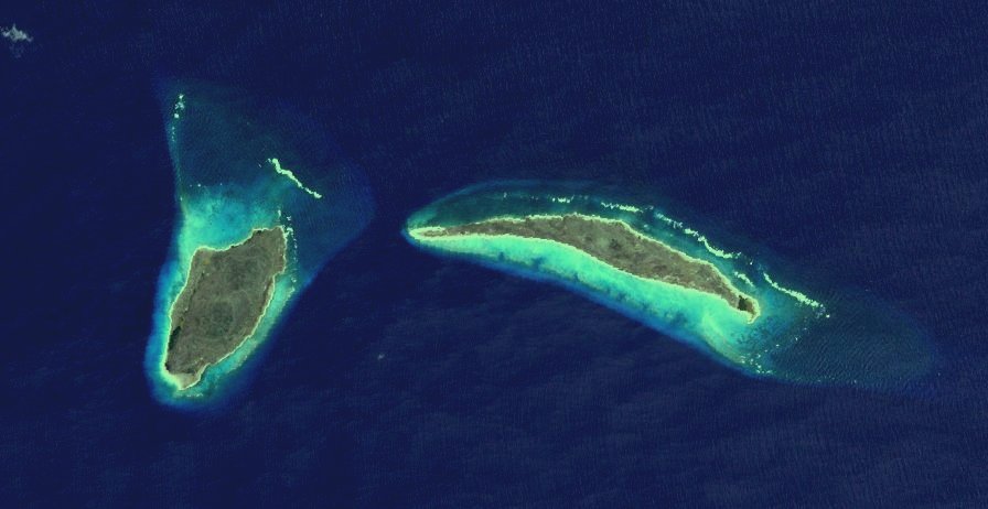
| |