Previous Page
Landfall Homepage
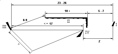
One of the arguments against the Plana-Samana track is that Columbus would have had to return to a place which he had visited before(since Crooked lies quite close to Fortune); and since there is no explicit mention of Isabela (Island IV) being close to Santa Maria (Island II), the implication is that the two islands are far apart. This idea is countered by another beautiful internal consistency in the Diario, as shown in Figure 7. Since the distance from III to II is 8 or 9 leagues "almost east-west" (C6), and the distance east along II is "ten or more" leagues, and the east-to-west distance from Island II (Santa Maria) to Island I (San Salvador) is 5 to 7 leagues, this means that the total E-W distance from I to III is 23+ to 26+ leagues. Since we previously determined from internal descriptions that the distance from III to IV is 17 leagues or less, we now have an important result:
Distance z, from Isabela (IV) to San Salvador (I), is 6+ to 9+ leagues E-W, or more.
|
|
Figure 7: The relative positions of the four islands, based solely on the descriptions in Columbus's log. The distance from Island I to Island III can be measured both via Island II and via Island IV. |
|
|---|---|
This result is critical because on November 20, while sailing north of Cuba, Columbus tells us the distance from Isabela (IV) to San Salvador (I): 8 leagues.
Bingo again! We now have a beautiful and internally consistent cycle of distances among these four islands. To restate the case, the Diario gives us two different ways of figuring the total east-west distance from Island I (San Salvador) to Island III (Fernandina): one way via Island II and another way via Island IV. Both of these measurements are substantially consistent with each other. But this internal consistency of the Diario breaks down if we assume that any one of these distances is in miles instead of leagues; so the Conception theory, which measures coastlines in miles, founders. And this internal consistency of the Diario also breaks down if we assume that Columbus was using two different lengths for a league; so the Watlings theory, which measures in two different leagues, also founders. There are only two theories left: Plana and Samana.
The actual distance from Fortune, the Plana-Samana Island IV, is 11 to 13 leagues in each case (Plana or Samana), depending on the exact length taken for a league. For the Plana-Samana track we must assume that Columbus did not actually see the distance from San Salvador to Isabela, but instead calculated it, perhaps in a manner similar to the way I have done in Figure 7; and further, that his computation was somewhat in error. This explanation is not entirely satisfactory, and I have given it a 1 on the Scorecard. Nevertheless, this distance is much closer for Plana and Samana (an error of 3 to 5 leagues) than for any other theory save Caicos. At Watlings and Conception, the distance is a huge 25 to 30 leagues. Mitchell accounts for this distance by supposing that the entire southern half of Long Island somehow slipped from Columbus's mind as he wrote this entry[35] --- an idea so strained that the theory could sink on that basis alone.
In addition to this internal inconsistency, the Columbus-couldn't-have-returned argument has been demolished by a recent discovery. Alex Perez[36] (fn 3) has noticed a remarkable description in Las Casas' Historia de las Indias;[37] the relevant passage takes place just prior to Columbus leaving Fernandina --- in search of Saometo, the native name for Island IV.
Because the Indians, which he had taken in the first island of Guanahaní or San Salvador, told him and indicated through signs that the island of Saometo [IV], which had been left behind, was larger[38] than Fernandina [III], and that they should return to it (and they must have done this in order to get closer to their land, from where he had taken them), the Admiral decided to turn around toward the east . . . .
Two things are clear from this: first, that Saometo had been left behind during the trip from Island I to Island III; and, second, that returning to Saometo would bring the natives of Guanahaní closer to their home. Perez has speculated that Las Casas had access to Columbus's map at the time he wrote this, which would account for these geographical concepts which are not immediately obvious in the Diario. In any case, this startling new evidence provides another heavy burden for all theories save Plana and Samana.
Regardless of which theory one supports, the important point is this: any theory, to be viable, must at least approximately fit the internally consistent cycle of distances among the four islands. Any theory that cannot is in trouble. Of all landfall theories that have been advanced, only two, Plana & Samana, are even remotely consistent with this internal cycle.
And of these two, Plana must be preferred for three reasons. First: Columbus saw a light on the night of October 11 at 10 o'clock. From Plana, the island of Mayaguana lies about 40 miles east; the light he saw was on Mayaguana, somewhat to the west of south. [Note: since "landfall" refers to sighting, then, technically, this paper is actually suggesting that Mayaguana might have been Columbus's first landfall. Or: lightfall?] From Samana there is no such island to the east, and thus nowhere[39] for that light to be.
Second, Plana has a coast that runs north-northeast, as Columbus describes the coast of San Salvador. Samana has no such coastline.
Finally, and most importantly, Plana agrees with Columbus's description of Island II (F6) that "the face which is toward San Salvador runs North-South": the single most important description (C11) in the Diario fits Plana perfectly, but it does not fit Samana, nor any other possible landfall site.
In contrast, there is hardly one description in the Diario that can
be decisively said to fit Samana better than Plana. The objection that
Plana is two islands is based not on any firm evidence in the Diario,
but rather on a presumption (contra E9), in the supposed absence of
such evidence. The biggest strength of the Samana theory is the track
after San Salvador, which Plana shares; and the biggest weakness of the
Samana theory is the description of San Salvador itself, which Plana
wins easily. Clearly, Plana is by far the best fit to the descriptions
in the Diario, and sets a new standard --- by which all other theories
must henceforth be judged.
 |
|
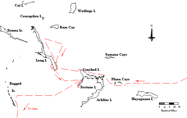
Figure 8: The route of Columbus through the Bahamas (dashed line). |
|
|---|---|
Return to the Plana Cays page.
Return to the Columbus Landfall Homepage
[1]Keith Pickering is a scholar of exceptional mathematical-technical abilities & knowledge, who shares DIO's interest in both historical & hysterical astronomy. He & his wife Nath live under the clear skies of rural Minnesota. (Address: 10085 County Road 24, Watertown, MN 55388; phone 612-955-3179.) Return.
[2]Samuel Eliot Morison, Admiral of the Ocean Sea, 1942; Little, Brown, & Co., Boston. Return.
[3]My knowledgeable friend Arne Molander (whose criticisms have contributed materially to the improvement of this paper) disagrees strongly with many of the views expressed here. Those who wish to hear his side of the ongoing landfall debate may contact him at 19131 Roman Way, Gaithersburg, MD 20879 (telephone 301-948-7341), whence Arne frequently circulates a useful Columbus Landfall Round Robin, featuring a spectrum of viewpoints. The Round Robin's printed list of Contributors includes Joe Judge (Senior Editor emeritus, National Geographic), Jim Kelley, & the present writer. The list of Observers includes Charles Burroughs (Washington Area Explorers Club), Dennis Rawlins (DIO), Bradley Schaefer (Yale University, Physics Department), & John Russell-Wood (Johns Hopkins University, History Department). Microfilm copies of much of the Round Robin correspondence are available from David Henige, Memorial Library, 728 State Str., Madison, WI 53706 (phone 608-262-6397; fax 608-265-2754). [Note by DR: Correspondence-fallout from the present paper is at least as likely to appear in the Round Robin as in DIO. In fact, some has already appeared in the Round Robin --- because a version of this paper (subsequently revised) has been circulating privately since 1992.] Return.
[4][Note by DR: much of the computer work for Judge's important National Geographic studies, on the Columbus landfall question, was supervised by my late friend, the Minnesota scientist-explorer Robert Lillestrand, of Control Data Corp. (Lillestrand was also the scientist primarily responsible for the 1968-1969 precise determination of the northernmost point of land in the world, Kaffeklubben Island, which had been first reached by the premier US arctic explorer, Robert Peary, in 1900 May.)] Return.
[6]John W. McElroy, "The Ocean Navigation of Columbus on His First Voyage", The American Neptune, I (1941), pp.209-240. Return.
[7]Luis Marden, "The First Landfall of Columbus", National Geographic, November 1986, pp.572-577. Return.
[8]Philip L. Richardson and Roger A. Goldsmith, "The Columbus Landfall: Voyage Track Corrected for Winds and Currents", Oceanus, 30 (1987), pp.3-10. Return.
[9]W. Van Bemmelen, "Isogonen-karten fur die Epochen 1500, etc.", Appendix to "Die Abweichung der Magnetnadel", a supplement to Observations of the Royal Magnetical and Meteorological Observatory at Batavia, XXI (1899) Batavia. Marden did not quote the reference directly. He apparently used the isogonic lines as reproduced in McElroy's 1941 article, as Van Bemmelen did not continue his isogons past 60° W and McElroy extrapolated them. Return.
[10]Ronald T. Merrill and Michael W. McElhinney, The Earth's Magnetic Field, 1983; Academic Press, London and New York, pp.84-86 & 99-101. Return.
[11]Merrill & McElhinney 1983. This study (among others) also suggests that the 15th century was a period of rapid movement of the NGP; thus, even if we had a better understanding of the position of the NGP at epoch 1500, its position merely a decade earlier might have been nontrivially different. (Curiously, our knowledge is so fuzzy in this connection, that Columbus's reports may contribute as much to it, as it can tell us about Columbus's reports.) Return.
[12]Roger A. Goldsmith and Philip L. Richardson, "Numerical Simulations of Columbus' Atlantic Crossings", WHOI-92-14, February 1992. Return.
[13]Throughout this paper's tracings of Columbus's inter-island route, we will implicitly identify his compass headings with true ones --- i.e., we are presuming effectively zero compass variation in this region in 1492. For transatlantic tracking, the zero-variation assumption would be disastrous; but the errors it introduces over short Bahamian distances are trifling. Return.
[14]Oliver Dunn and James E. Kelley, Jr. The Diario of Christopher Columbus's First Voyage to America, 1492-1493, 1989: University of Oklahoma Press, Norman (OK) and London, p.113. Return.
[15]James E. Kelley, Jr. "In the Wake of Columbus on a Portolan Chart", Terrae Incognitae, 15 (1983), pp.102-107. Return.
[16]Kelley 1983 pp.94-97. Kelley's paper brilliantly demonstrates that Columbus's distance-estimates along the north coast of Cuba were inflated because of the half-knot current he was working against. It was these same inflated estimates which earlier led Morison to postulate that Columbus used an ultra-short "land league" when measuring coastlines. Return.
[17]Gustavus V. Fox, "An Attempt to Solve the Problem of the First Landing Place of Columbus in the New World", Report of the Superintendent of the U. S. Coast and Geodetic Survey (Appendix No. 18, June 1880). Washington: Government Printing Office, 1882, p.47. Return.
[18]Steven W. Mitchell, "Columbus's Track from San Salvador to Cuba: a New Conception", unpublished lecture notes from U. S. Naval Institute seminar of 24 April 1992, Annapolis. It is true that, at several points in Las Casas's transcription, he originally wrote "leagues" and then crossed this out, substituting "miles". (Columbus's "mile" was considerably smaller than our modern 1852 meter nautical mile.) It seems to me that these false starts simply reinforce the idea that all measurements in the original log were in leagues, and Las Casas was converting to miles as he went along. Since the possibility of transcription error is enhanced when the copyist must pause for such a calculation, the fact that all such instances occur during the recording of miles suggests that miles (not leagues)were the result of these calculations. Return.
[19]Fox 1880, pp.47-48. Return.
[20]David P. Henige, "Samuel Eliot Morison as Translator and Interpreter of Columbus's diario de a bordo", Terrae Incognitae, 20 (1988), p.85. Return.
[21]Arne Molander, "Egg Island is the Landfall of Columbus", San Salvador Conference (1st: 1986; College of the Finger Lakes, Bahamian Field Station), pp.161-169. Return.
[22]Richard Rose, "Lucayan Lifeways at the Time of Columbus", San Salvador Conference (1st: 1986; College of the Finger Lakes, Bahamian Field Station), pp.328-329. Return.
[23]The correct English translation of bien grande is much in dispute. For what it's worth, I prefer "good sized" --- which nicely reflects the ambiguity of the Spanish. Return.
[24]Following Dunn & Kelley 1989, p.73; with the final three words added by this author. Return.
[25]Joseph Judge, "Columbus's First Landfall in the New World", National Geographic, 170 (November 1986), pp.589-590. Return.
[26]Dunn & Kelley 1989, p.77. Return.
[27]Dunn & Kelley 1989, p.77. Return.
[28]Ramon J. Didiez Burgos, Guanahaní y Mayaguain, 1974: Editoria Cultural Dominicana, Santo Domingo, p.171. Return.
[29]Robert H. Power, "The Discovery of Columbus's Island Passage to Cuba", Terrae Incognitae, 15 (1983), pp.165-167. Return.
[30]Computation: 2.1[50^{1/2} + 15^{1/2}]/2.67 = 23 nmi, or 8.6 leagues. Return.
[31]Whether computed by plane or spherical trigonometry, the results (for such a small spherical triangle)naturally agree almost perfectly. Return.
[32]Dunn & Kelley 1989, p.99. Return.
[33]Dunn & Kelley 1989, p.103. Return.
[34]Alejandro R. Perez, Columbus's First Landfall in America and the Hidden Clues in his Journal, 1987: ABBE Publishers, Washington, D.C., p.68. Return.
[36]Alejandro R. Perez, "Did Las Casas Have Columbus's Map?", August 20, 1992. Letter to Molander's Columbus Landfall Round Robin. Return.
[37]The Historia was the major work of Las Casas, in preparation for which he copied and paraphrased the Diario. Since the relevant sections of the Historia are clearly drawn from the Diario, landfall-dispute historians have mostly ignored the Historia, rightly preferring the more original source. However, the Diario was not the only source that Las Casas drew upon in preparation of the Historia. Return.
[38][If so, and if the Plana track is true, then "Saometo" refers not only to Fortune but to Crooked and perhaps even Acklins, in combination. (If Columbus, too, sometimes mentally combined nearly-contiguous Fortune & Crooked, this helps ease the III-to-IV directional problem of F12: Figure 6 vs. Figure 8.Note also F11 & F13: net sailing direction not due eastward.)] Return.
[39]Why did Columbus not see Mayaguana but later did notice Plana? Assuming the Plana track, we note: [a] Plana's distance at discovery was less than that of Mayaguana when the light was reported. [b] The Moon rose (i.e., apparent terminator on sealevel horizon) at 10:30 PM, Local Apparent Time --- thus, the well-risen moon's light upon Plana was stronger and more direct than the oblique rising-moon's light falling upon Mayaguana earlier. [No irresistible alternate ocular theories explain the 10 PM light; but, to try our best, we check out the sky: The 2nd magnitude star Ras Alhague set (azimuth A = 284° = 14 degrees north of due west) at 9:51 PM LAT (sealevel); at 9:30 PM, apparent h = 4°27', A = 282°, zero-aerosol post-extinction magnitude mu = 3.6; at 9:40 PM, h = 2°.3, A = 283°, mu = 4.3; at 9:45 PM, h = 1°1/4, A = 284°, mu = 5.0. (The h cited here are sealevel: unenhanced by 7' dip, for height 15 m.) Morison (fn 2) 1:297 is understandably skeptical: for the claimed light-sighting, Columbus "demanded and obtained the annuity of 10,000 maravedis promised by the Sovereigns to the man who first sighted land."] Return.